


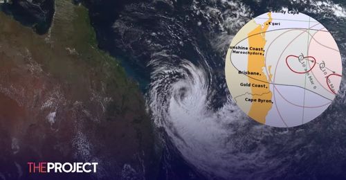
Professor of atmospheric sciences Liz Ritchie has said that whilst the cyclone is only considered "moderately intense" it can still be very impactful.
Ritchie advised that winds will likely range from 90-110 kph and there will be heavy rainfall on the south side of the cyclone.
She expects that there could be ocean swells around 10 m in height as the cyclone is over the water.
Due to the rainfall and ocean swells, flooding and flash flooding is expected and should be prepared for as much as possible.
Liz Ritchie advised that the intensity of the flooding will be impacted by the time that the cyclone makes landfall.
She told ABC Coffs Coast, "If it comes in when you're on a low tide, then it's not so impactful, but if it comes in on your high tide, then it can be quite impactful."
Residents have also been warned to prepare for potential power outages.
If power lines are impacted, crews will need to wait until it is safe to make repairs to return power to the area.
The Energex Area Manager Renee Kath has said "We will have all available resources on the ground as soon as it's safely possible to do so, and obviously factoring there are areas that are harder to get to such as areas that may have had landslides."
Federal Emergency Minister Jenny McAllister has warned communities to be aware and prepared for the risks in the coming days.
"This will be a difficult time for communities that have been through flooding in the recent past and I am incredibly conscious that in northern NSW this comes very close to the three-year anniversary for those big 2022 floods," she says.
"What I want people to understand is that we are getting ready."
"But at home there are things people can do to get themselves ready. Principally that means knowing their own risk. Monitoring the information about when and where the cyclone may cross and understanding the risks that might arise."