


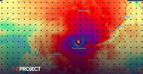
Tropical Cyclone Zelia is set to cross Western Australia's Pilbara coast near Port Hedland around 3 pm local time on Friday as a category five system, producing winds up to 300km/h.
Port Hedland local Tracey Heimberger was keeping her fingers crossed her house "holds together" after opting to sit out the storm with her partner at home.
"I'm a bit scared actually. It's going to be a hell of a storm," she told AAP.
"It's started getting really gusty already. Hopefully, our house holds together.
"We've done all preparations we can. We've even put our passports in zip-lock bags."
Ms Heimberger was also concerned for the safety of locals, saying many homes in the town weren't designed to withstand a category-five cyclone.
"Especially people living in our outlying communities. I really hope they've got to town."
The Bureau of Meteorology said wind gusts of 120km/h had already been recorded near Port Hedland, with rainfall totals slowly increasing.
In the last 24 hours, Wallal Downs recorded 90mm after downpours of several 100mm fell in a matter of days.
A "shelter indoors now" alert has been issued for Pardoo Roadhouse to Whim Creek and west to Marble Bar.
"It is too late to leave," the Bureau of Meteorology said.
Other towns like Karratha, Dampier, Tom Price, and Eighty Mile Beach have been warned to prepare to take shelter.
Shops, schools, roads, airports and ports in the state's northwest have closed in preparation for the dangerous system.
Winds up to 150km/h are expected to impact coastal areas but 300km/h gusts are forecast for the region the cyclone was expected to cross, east of Port Hedland.
"These are extremely destructive winds. Winds so powerful it can take out trees, power lines and entire houses and really destroy anything in its path," meteorologist Angus Hines said on Friday.
Rainfall up to 500mm was expected to inundate the region with a significant storm tide also forecast that may lead to coastal road and home flooding.
Flash flooding has already begun to inundate roads with reports a road train was washed off a Marble Bar bridge.
Experts are extremely concerned about the cyclone's impact on northwest WA, particularly iron ore hub Port Hedland.
"Even buildings and infrastructure built to the highest cyclone rating standards will receive some structural damage from the predicted extreme winds in the core of the cyclone," Professor Steven Turton from Central Queensland University said.
Prof Turton said offshore sea temperatures are feeding the cyclone which may cause significant damage to the remote area.
"Despite the small size of the system, its slow forward motion will mean prolonged extreme winds and intense rainfall around the core as it approaches and crosses the coastline," he said.
Evacuation centres have been set up at Karratha and South Hedland, with major highways near Port Hedland and regional airports closed.
Meanwhile, north Queensland was recovering from its own flooding disaster, with power restored to 30,000 homes after a fortnight of record falls that caused two deaths and hundreds of evacuations.
The federal government has announced $84.8 million to 18 local government areas in northern and western Queensland to undertake major infrastructure and flood mitigation upgrades.
With AAP.