


Far north Queensland residents are bracing for power, internet and water cuts as Tropical Cyclone Jasper bears down on the coast, bringing damaging winds, heavy downpours and flash flooding.
Evacuation centres have been set up, and hundreds of support teams, including energy company workers, are heading north to assist as the cyclone approaches.
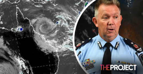
On Monday, Jasper was about 600km east of Cairns and 530km northeast of Townsville.
Deputy Premier Steven Miles said it was expected to re-intensify and make landfall between Cape Flattery and Townsville on Wednesday.
"While it's currently been downgraded to a category 1 cyclone, it is expected to re-intensify into a category 2," he told reporters on Monday.
There is a significant risk of flash flooding and a storm surge for the Queensland coast stretching from Cairns to Townsville.
A tropical cyclone warning was issued on Monday, effective from Cooktown to Townsville, including Cairns, Innisfail and Palm Island.
"A warning means we can expect impacts from the cyclone within 24 hours and this includes gale force winds," the Bureau of Meteorology's Laura Boekel said on Monday.
"At this stage, the most likely scenario is we will see a category 2 crossing the coast sometime on Wednesday."